 |
AGE GeoGlobe
Fact Sheet (pdf) |
AGE's GeoGlobe is a 3D based visualization and dissemination tool designed to make the discovery and exploitation of geospatial information more intuitive and productive within the DOD user community. AGC's GeoGlobe is based on Skyline Software's SkylineGlobe suite of products. This enterprise software allows users to access AGC's geospatial data archives and products through a locally installed 3D client for Internet Explorer and Internet Information Services (IIS).
|
 |
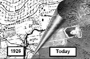
Common Map Background
Fact Sheet (pdf) | Product Catalog
CMB provides digital map and image data to the Warfighter. CMB utilizes a comprehensive digital data library and custom ArcGIS toolset designed to dramatically reduce the time and expense required to acquire, manage and distribute geospatial.
|
 |
Geospatial Information Library
|
The Geospatial Information Library focuses on physical geography, terrain analysis and military hydrology, and provides support to all authorized Army, DoD, and other government organizations.
|
 |
Historical Photo Analysis
Fact Sheet (pdf) | Product Catalog
Historical Photographic Analyses (HPA) is used by analysts to address environmental concerns related to land use change, such as historical wetland evaluation, shoreline change, watershed/land use mapping and produces a variety of baseline environmental analyses.
|
 |
Military Capabilities Studies
|
The MCS is a Department of Defense program designed to provide a compendium of intelligence data on the military, economic, political and environmental resources of a country. MCSs are intended to serve as a ready reference document for national, operational and tactical planners.
|
 |
Urban Tactical Planner
|
The Urban Tactical Planner, or UTP assists the planning and visualization of military operations in the world's urban areas. The urban environment is displayed as an aggregate of features that affect urban area operations, such as building form and function (broken out as polygons of like-building types), building height, vertical obstructions, terrain feature, bridges, lines of communication, key cultural features, landmarks, etc. These features are shown as themes or layers that can be displayed, on-or-off, as decided by the user.
|
 |
WATER RESOURCES DATABASE (WRDB) PROGRAM TERMINATION
Effective 30 September 2019 the DoD Water Resources Data Base and Water Detection Response Team will cease operations. The Department of Army determined deactivate and divest this support mission after FY19. In accordance to this guidance the Army Geospatial Center will discontinue further feature development and services related to DoD Water Resources mission support to include all training, requests for information, web-based services and data base maintenance. Standalone, dated versions of the water resources data base will continue to reside in current DoD systems without being updated. This DoD water resources mission requirement has not been transferred to any other organization.
|