Systems Engineering
One of the strengths of the Army Geospatial Enterprise (AGE) is the standardization of common support services associated with the development, implementation and support of the Standard Sharable Geospatial Foundation (SSGF).
AGE’s SSGF Enabling Technology Support Services (ETSS) provide systems engineering technical guidance to Programs of Records (PORs), Program Managers (PMs), and Computing Environments (CEs) to enable them to meet their geospatial requirements. Each SSGF ETSS Detailed-Engineering Change Proposal (D-ECP) provides technical standards, architecture products, use cases, data flows, data schemas, and an implementation plan to further enable the SSGF Cross Cutting Capability (CCC) thru interoperability and standardization across the Common Operating Environment (COE).
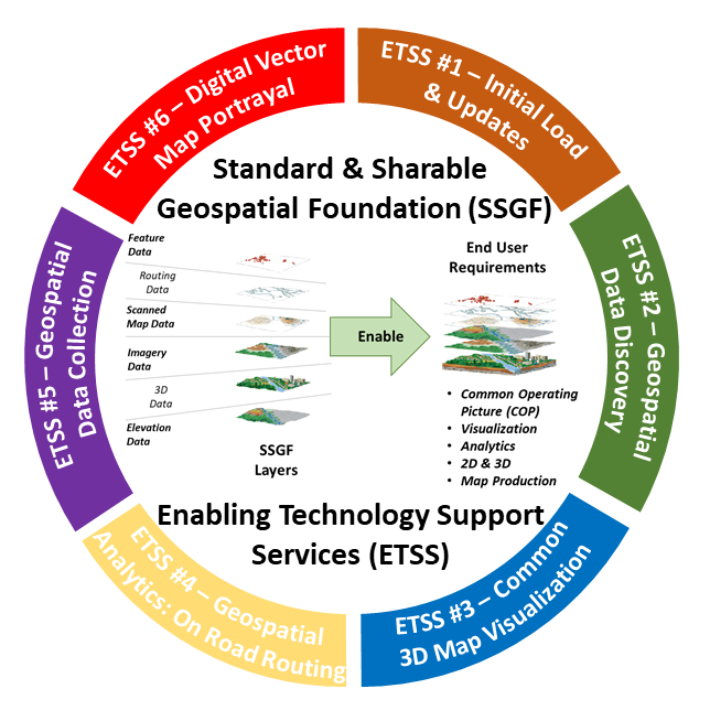 |
| The six SSGF ETSS’s provide technical guidance to implementing Programs of Records, Program Managers and Computing Environments to enable the Army Geospatial Enterprise and increase geospatial standardization and interoperability across the Common Operating Environment. |
SSGF Enabling Technology Support Services
- SSGF ETSS #1 - Initial Load & Updates. Initial Load & Updates provides a methodology to automate the initial load and updates of Standard & Sharable Geospatial Foundation (SSGF) data including geospatial feature, elevation, and/or imagery data for utilization in digital information systems at all echelons throughout operations. Implementing systems are provided with the SSGF Data & Services Implementation Profile (SDSIP), which enables automation of initial loads and updates from SSGF Provisioners to SSGF Consumers.
- SSGF ETSS #2 – Geospatial Data Discovery. Geospatial Data Discovery prescribes a standard automated geospatial data discovery service for data holdings across the Army Geospatial Enterprise. The U.S. Army Map Resources website was developed and stood up by AGC to support geospatial data discovery. Implementing systems are provided with a set of SSGF Favorites bookmarks for installation on their systems.
- SSGF ETSS #3 - Common 3D Map Visualization. Common 3D Map Visualization prescribes a standardized method for visualization of SSGF 3D Data. The Detailed-Engineering Change Proposal provides technical guidance on 3D Data formats, 3D Data storage requirements, and tools to Generate, Manage, Analyze and Disseminate 3D data and was developed in coordination with the Army’s 3D Executive Order (EXORD).
- SSGF ETSS #4 - Geospatial Analytics (On-Road Route Planning). Geospatial Enabled Analytics (On-Road Route Planning) enables and standardizes on-road route planning on digital information systems at all echelons throughout operations. Route Planning prescribes the data models, standards, application programmer interfaces, and exchange mechanisms for on-road routing. Implementing systems are provided with the Route Exchange Model (REM) and Routing Application Program Interface (RAPI) tools and are recommended to use Army HERE and OpenStreetMap (OSM) data sets to support their on-road routing requirements.
- SSGF ETSS #5 - Geospatial Data Collection. Geospatial Data Collection prescribes a unified methodology to collect geospatial feature, elevation, or imagery data from all echelons throughout operations. Implementing systems are provided with standardized forms, pre-formatted United States Message Text Format (USMTF) & Variable Message Format (VMF) message, XML schemas to support the collection of geospatial data.
- SSGF ETSS #6 - Digital Vector Map Portrayal. Digital Vector Map Portrayal prescribes the standards and support services for the common visualization of vector data across the Army Geospatial Enterprise, where data, symbology, and encoding combine to make a map. Implementing Systems are provided with a Software Developers Kit (SDK) which includes Style Encodings, Symbol Libraries, Sample Data Sets and Tools to assist and enable system developers.