 |
AGE GeoGlobe
Fact Sheet (pdf) |
AGE's GeoGlobe is a 3D based visualization and dissemination tool designed to make the discovery and exploitation of geospatial information more intuitive and productive within the DOD user community. AGC's GeoGlobe is based on Skyline Software's SkylineGlobe suite of products. This enterprise software allows users to access AGC's geospatial data archives and products through a locally installed 3D client for Internet Explorer and Internet Information Services (IIS).
|
 |
AGC Imagery Office
Fact Sheet (pdf)
The AGC Imagery Office (AIO) functions as the U.S. Army's commercial imagery acquisition agent and monitor. This action is designed to prevent Army agencies and organizations from duplicating imagery acquisition/data purchases.
|
 |
Buckeye
Fact Sheet (pdf) | Product Catalog
The BuckEye mission is to rapidly collect, process and distribute Unclassified high resolution and high accuracy color imagery and elevation data. BuckEye collected over 85,000 square kilometers in Iraq, and has collected over 160,000 square kilometers in Afghanistan. There are several fixed winged and unmanned systems currently operating in Afghanistan. BuckEye's requirements and tasking are controlled at the International Security Assistance Force (ISAF) level. A majority of the imagery and LIDAR is processed in-theater to provide rapid tactical response.
|
 |
Common Map Background
Fact Sheet (pdf) | Product Catalog
CMB provides digital map and image data to the Warfighter. CMB utilizes a comprehensive digital data library and custom ArcGIS toolset designed to dramatically reduce the time and expense required to acquire, manage and distribute geospatial.
|
 |
Hypercube
HyperCube is a Macintosh and Windows application program specifically directed to the analysis and display of multi and hyperspectral imagery. This includes the static and dynamic display of the image cube and the generation of spectral classifications using both imagery and spectral libraries. In addition, HyperCube contains functions to filter, warp, mosaic, reformat, calibrate, combine, photogrammetrically project, stereo compile and to perform arithmetic on imagery and data.
|
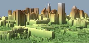 |
LIDAR
|
Light Detection and Ranging (LIDAR) sensors provide high resolution and high accuracy 3D geospatial data. It can be used by U.S. Forces in Iraq for improved situational awareness, battlefield visualization, mission planning, and force protection.
|